
In a first, the four offshore wind leaseholders in waters south of the Vineyard appear to be going in the same direction — literally. In a joint statement Tuesday, the four firms announced they had agreed on a uniform turbine orientation and spacing for their projects.
A proposal the companies submitted to the U.S. Coast Guard for analysis says that turbines in the state’s proposed 742,000-acre wind energy area will be uniformly spaced one mile apart and oriented in an east-west direction. The agreement comes after the coastal engineering firm W.F. Baird and Associates conducted a study that evaluated the uniform layout proposal using international vessel safety guidelines.
In the joint statement, the companies said the agreement came in response to key New England maritime stakeholders.
“This uniform layout is consistent with the requests of the region’s fisheries industry and other maritime users,” the statement said in part. “In addition, independent expert analysis provided to the USCG confirmed that this uniform layout would provide for robust navigational safety and search and rescue capability by providing hundreds of transit corridors to accommodate the region’s vessel traffic. We look forward to continuing to work with the USCG, the Bureau of Ocean Energy Management, coastal states, the fisheries industry, and other stakeholders involved to ensure continued coexistence of every ocean user in the region, including offshore wind.”
Vineyard Wind, which plans to develop an 84-turbine wind farm about 15 miles south of the Vineyard, had initially proposed orienting their turbines in a northeast-southwest direction, spaced at least eight-tenths of a mile apart. According to earlier statements from the company, that decision had come from interacting with fishermen who felt the diagonal spacing would make the turbines easier to transit.
The Vineyard Wind project has been on hold since the federal Bureau of Ocean Energy Management decided late this summer to delay an environmental impact statement on the development while it examined the cumulative impact of the eastern seaboard’s wind energy boom.
In a statement issued late Tuesday, BOEM acknowledged the new proposed layout and also suggested that the EIS would not be delayed much longer.
“This new information will be included and analyzed in the broader cumulative impacts analysis that the department is working on,” the statement said. “The department continues to work closely with the U.S. Coast Guard, the National Marine Fisheries Service and other federal agencies on the review of these layouts. We anticipate publishing the supplemental environmental impact statement and receiving public comments early next year.”
Meanwhile, an early drawing from Mayflower Wind — a joint venture between Shell Oil and EDP renewables that recently won the state’s second offshore energy bid — showed that the company also would orient its turbines in an east-west direction. Information on proposed spacing plans was not available.
As a result all four companies, including Equinor and Bay State Wind, which hold lease areas that straddle Vineyard Wind, have said they will adhere to a uniform orientation and spacing for their proposed turbines, based on the Baird report.
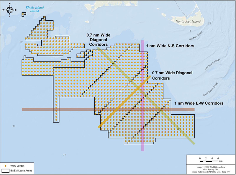
The Baird report analyzed vessel traffic through the proposed wind energy area south of the Vineyard in both Massachusetts and Rhode Island waters, using data from ship transponders collected in the Automatic Identification System over the past two years. Density plots showed that turbines arranged in an east-west orientation with one nautical mile separation would allow for adequate transit corridors for all boats under 400 feet. The study concluded that larger boats would generally transit around the wind energy area.
“This layout would accommodate the wide range of ports, destinations, and routes observed by fishing vessels, which makes up most of the traffic going through the [wind energy area], as well as the majority of observed vessel tracks through the [wind energy area] thereby by accommodating the wide range of reported fishing practices in the region,” the report concluded.
If all offshore lease areas are eventually built out, the arrangement would provide 40 transit corridors in the east-west direction, 56 in the north-south direction and 48 in the northwest-southeast direction. Even though very few vessels travel in the southwest-northeast direction, there would be 87 in that orientation as well. The diagonal transit corridors would only be 0.7 nautical miles in width.
“Given the many advantages of the proposed 1x1 nm turbine layout, the New England Leaseholders are proud to be working together to propose a collaborative solution to concerns that have been raised by stakeholders about the full-build out scenario of the [New England wind energy area],” a letter signed by all the leaseholders and addressed to the Coast Guard reads in part. “This proposed layout responds to input and requests from many stakeholders and creates an opportunity that we believe accommodates all ocean users.”


Comments (2)
Comments
Comment policy »