
An engineering report examining the stability of scenic East Chop Drive in Oak Bluffs concludes the fragile coastal slope is extremely unstable and showing signs of distress and imminent failure.
The eight-page draft report from the firm of Stearns and Wheler recommends that the town repair the bluff as quickly as possible by both reshaping the coastal bank and installing stabilizing materials such as a concrete block system, heavy riprap, sheet piling or a specially designed mechanically stabilized earth wall.
A public road, East Chop Drive is owned by the town; the bluff is owned by the East Chop Association. Town leaders are in talks with members of the association about how to solve the problem.
The engineering report was commissioned by the town in 2006. The report is dated Oct. 31 of last year, although a final version has yet to be released. The draft report has largely remained out of public view, and has yet to be discussed at a public meeting or hearing. The report was prepared by Stearns and Wheler with the assistance of Deere and Ault consultants and the firm Geo-Logic.
Engineers from the three firms visited East Chop on Sept. 8 and 9 to conduct a subsurface exploration using standard penetration testing to determine the strength properties and behavior of the soils beneath the surface The work included three 60-foot deep test borings, taken in the center of the northernmost travel lane of East Chop Drive.
The soil sampling was then conducted at five-foot intervals underground.
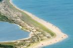
The coastal bank runs parallel to East Chop Drive and consists of 20 to 40-foot slopes that dip downward at a steep angle. Most of the slope is covered with vegetation — beach grass, rosa rugosa and brush, which the report concludes may be the only thing holding up portions of the bluff.
With its ocean overlook and distant view of Woods Hole, East Chop Drive offers one of the most unique vistas on the Island for pedestrians and motorists alike. The roadway was ravaged during Hurricane Bob in August of 1991, and there has been serious concern about both stability and liability since then.
The road was closed to traffic for several months in 1992 and 1993 while workers trucked in tons of granite riprap quarried from Rhode Island. Efforts to save the bluff date back to 1929 when a wooden bulkhead was installed.
The bulkhead has since been partially buried by a wave break made of heavy riprap.
The engineering report concludes the upper slope close to the road is in poor condition; numerous scarps, sloughs and eroded gullies were observed by engineers when they made their site visit. The report also notes that much of the natural brushy vegetation and trees have been removed by residents within the last few years and replaced with beach grass to provide a better view.
The report concludes that the soil directly underneath the road offers little stability. Sand collected during the testing is classified as poor, and soils collected in borings are consistent with that of sandy outwash material.
The report predicts that an extreme weather event such as a severe northeaster or a hurricane could damage the slope at the base of the bluff and threaten East Chop Drive above. “Rapid deterioration with significant erosion may occur if waves start to overtop the heavy riprap wave break and contact the bottom of the upper slope. Periods of heavy rainfall may also destabilize local areas of the slope,” the report says.
The report recommends that heavy trucks not be allowed on East Chop Drive during periods of heavy rain or waves breaking on the upper slope. “Local traffic . . . should be limited during said storm events to the westbound lane as long as the eastbound lane shows no signs of distress (i.e. cracking). The roadway should be closed if the eastbound lane starts to show signs of distress,” the report says.
The report lays out four options for stabilizing the bluff.
The first is to install armor and heavy riprap to reshape the slope to a more stable angle. This would require cutting into the top of the slope and removing much of the vegetation, “thus leaving the slope in a precarious condition during construction and until vegetation is reestablished,” the report says.
The second option is to add a rock fill on top of the bluff to a height that would change the pitch of the slope to a more stable angle. The drawback of this technique, the report finds, is added weight. Another option is to install a mechanically stabilized earth wall made of precast concrete blocks.
The final option is to install a 20-foot-high anchored sheet pile wall at the top of the bluff that would allow the existing slope to be excavated to a flatter angle. The slope could then be armored with riprap and the remainder of the slope revegetated.
The engineering report concludes: “The subsurface materials are outwash sands with inter-bedded gravelly layers. The current slope is showing signs of distress and localized failures. The current slope does not meet minimum stability factors of safety. The slope may erode quickly if exposed to wave action.”
Oak Bluffs conservation commission chairman Joan Hughes said the town is in the early stages of working on a plan to stabilize the bluff and protect the roadway, although she said the repairs will be costly and could run into millions of dollars. But she said it is a problem that must be addressed.
“It’s a terribly urgent situation. I hate to say it, but one strong storm could knock part of the bluff into the ocean — and East Chop Drive along with it. And once that road is gone, it’s gone for good, because there is no way we would ever get approval to build another road,” Mrs. Hughes said.


Comments (3)
Comments
Comment policy »